
Community Information
What is the average age of floodplain data in Maryland?
Using the schedule for map production in 2017, the average age of the DFIRM products in the Maryland is 4 years with 75% of the State at 3 years or less. Currently, 4 of the 6 oldest floodplain mapping products are in production to be remapped. MDE is the Cooperating Technical Partner (CTP) on three of these products in Baltimore City, Baltimore County, and Montgomery County. FEMA’s Risk Assessment, Mapping and Planning Partners (RAMP) is producing the DFIRM product in Frederick County.
What is the NFIP?
Congress established the National Flood Insurance Program (NFIP) due to escalating costs to taxpayers for flood disaster relief. The NFIP is based on the agreement that if a community practices sound floodplain management, the Federal Government will make flood insurance available to residents in that community. FEMA maps include the Special Flood Hazard Area, which is the area that has a 1 percent or greater chance of flooding in any given year. Development may take place within the Special Flood Hazard Area provided that it complies with local floodplain ordinances that meet NFIP criteria.
What is a FIRM?
When FEMA maps flood hazards in a community or county, two products are produced a Flood Insurance Study (FIS) report and a Flood Insurance Rate Map (FIRM). An FIS is a narrative report of the community's flood hazards that contains prior flooding information, descriptions of the flooding sources, information on flood protection measures, and a description of the hydrologic and hydraulic methods used in the study. A FIRM illustrates the extent of flood hazards in a community by depicting flood risk zones and the Special Flood Hazard Area, and is used with the FIS report to determine the floodplain development regulations that apply in each flood risk zone and who must buy flood insurance. FIRMs also depict other information including Base (I percent annual chance) Flood Elevations (BFEs) or flood depths, floodways, and common physical features such as roads.
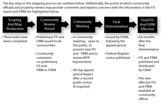
Why Are the Maps Being Updated?
Some communities within Maryland are now being shown a single set of countywide FIRMs. The most significant change is that the new maps have been prepared with updated base mapping and topography that will improve the accuracy of floodplain determinations. With this update a Digital Flood Insurance Rate Map (DFIRM) was produced that will be compatible with GIS (Geographic Information Systems). The improvements in spatial accuracy provided by the new base map, and the availability of electronic floodplain information should greatly enhance the ability to use the maps for planning, permitting, and insurance applications. The digital files will be available online when these maps become effective.
What Else Has Changed?
All flood elevations shown in this Flood Insurance Study are now referenced to the North American Vertical Datum of 1988 (NAVD 88). In order to perform this conversion, effective elevation values from the National Geodetic Vertical Datum of 1929 (NGVD 29) were adjusted downward by .81 foot. Hydrologic and hydraulic analyses for all riverine studies have been revised by the U.S. Army Corps of Engineers. Furthermore, all floodplains, including coastal flooding from the Chesapeake Bay, have been delineated using updated topography.
How do I Find Out if a Structure or Property is Located in the Special Flood Hazard Area?
You can locate a building or a lot by consulting the FIRM, or by contacting the floodplain administrator for your community. For help interpreting a FIRM, telephone the FEMA Map Assistance Center (FMAC) at 1-877-FEMA MAP (1-877-336-2627).
What is a Protest?
Challenges received during the appeal period that do not address proposed BFEs are considered "protests." Protests include, but are not limited to: challenges of floodplain boundary delineations based on more detailed topographic data; challenges of proposed regulatory floodway boundaries based on better modeling; requests that a Letter of Map Amendment (LOMA), Letter of Map Revision Based on Fill (LOMR-F), or LOMR be incorporated; base map errors; and omissions. Appeals and protests must be supported by scientific or technical data, provide proof of error, and provide sufficient data to make revisions. Certification of data by a Registered Professional Engineer or Licensed Land Surveyor may be required.
What is an Appeal?
Some flood studies result in new or revised BFEs. During the 90-day appeal period, community officials and others may object to the accuracy of the proposed BFEs. According to federal regulations, "The sole basis of appeal... shall be the possession of knowledge or information indicating that the elevations proposed by FEMA are scientifically or technically incorrect." Communities should coordinate with the FEMA Philadelphia office before submitting an appeal.
What Happens After the Appeal Period?
FEMA will issue a Letter of Final Determination and then provide the community with six months to adopt up-to-date floodplain management ordinances. If the floodplain ordinances in effect are satisfactory, they can be submitted in their current form. If ordinances need to be updated, communities should seek assistance from their State NFIP Coordinator or the FEMA office in Philadelphia. After the six-month compliance period, the new FIS and FIRM will become effective.
What if a Structure is Shown in a Different Flood Zone on the New Map?
The new map will not affect continuing insurance policies for a structure built in compliance with local floodplain management regulations and the flood map in effect at the time of construction. However, should the structure be substantially improved or substantially damaged (where damages or improvements reach 50% or more of the pre-damage market value) the entire structure will have to be brought into compliance with the floodplain requirements and the BFE in effect at the time any repairs take place.
Is There any Recourse if I Do Not Agree with the New Map?
Although FEMA uses the most accurate flood hazard information available, limitations of scale or topographic definition of the source maps used to prepare the FIRM may cause small areas that are at or above the BFE to be inadvertently shown within Special Flood Hazard Area boundaries. Such situations may exist in Anne Arundel County. For these situations, FEMA established the LOMA process to remove such structures from the Special Flood Hazard Area.
How Can I Request a LOMA?
To obtain a LOMA, the requester must complete a LOMA application form that is downloadable from: http://www.fema.gov/plan/prevent/fhm/dl_mt-ez.shtm. For a LOMA to be issued removing a structure from the Special Flood Hazard Area, federal regulations require that lowest adjacent grade be at or above the BFE. There is no fee for FEMA's review of the LOMA request, but the requester of a LOMA must provide all of the information needed for a review. Elevation information certified by a licensed surveyor is often required if an elevation certificate is not available.
Will LOMAs Issued under the Old Map be Valid under the New Map?
When a new FIRM becomes effective, it automatically supersedes previously issued LOMAs, LOMRs, and other map changes that have been issued for structures and properties on the revised FIRM panels. Recognizing that some map changes may still be valid even though the flood hazard information on the FIRM has been updated, FEMA has established a process for revalidating such map changes.
What is FEMA's Process for Revalidating Existing LOMAs and LOMRs?
To revalidate map changes, FEMA conducts a detailed comparison of the BFEs shown on FEMA's new FIRM and the lowest adjacent grade or lowest lot elevation of previously issued map changes. Those structures or properties that are above the BFE or are located in areas of the community that are not affected by updated flood hazard information are revalidated through a formal determination letter that is issued to the community's Chief Executive Officer when the new FIRM becomes effective. The revalidation letter is also mailed to each community's map repository to be kept on file and is available for public reference. Map changes that have been issued for multiple lots or structures where the determination for one or more of the lots or structures have changed cannot be automatically revalidated through the administrative process described above. To request that FEMA review such map changes (i.e., those that are not included in the revalidation letter), please submit the following to FEMA:
- A letter requesting the re-issuance (provide the case number of the LOMA to be reissued); and
- A copy of the LOMA to be reissued, if available.
FEMA will review the case file and issue a new letter reflecting its new determination.
How can I purchase flood insurance?
A policy may be purchased from any licensed property insurance agent or broker who is in good standing in the State in which the agent is licensed or through any agent representing a Write Your Own (WYO) company. Call 1-800-720-1093 or visit floodsmart.gov to find a flood insurance agent near you.
What Factors Determine Flood Insurance Premiums?
A number of factors are used to determine flood insurance premiums, including the amount of coverage purchased, the deductible, location, age, occupancy, and type of building. For newer buildings in floodplains, the elevation of the lowest adjacent grade (the lowest ground touching the structure), or lowest floor relative to the BFE will also be used to rate the policy.


Preliminary Schedule
- St. Mary's County - November 2022: Riverine
- Montgomery County - July 31, 2023: Riverine
- Howard County - August 2025: Riverine
Effective Schedule
- Frederick County - August 2023: Riverine (completed)
- Baltimore County - November 2023: Riverine
- St. Mary's County - May 2025: Riverine
- Montgomery County - Spring 2026: Riverine